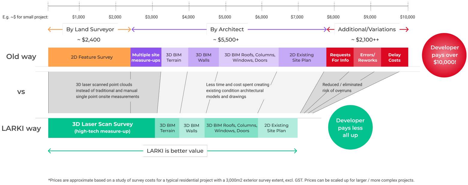
Compared to a traditional 2D survey with only a few hundred site data points, the 3D laser scanned Point Cloud surveys are made up of millions of site data points in 3D, so you have the critical spatial information you need, when you need it.
3D Point Clouds can then be used to generate more accurate existing condition Building Information Model (BIM) and feature survey drawings.
The Platform helps you to quickly and remotely order, download, measure and collaborate online.

Instantly get medium resolution 3D Point Clouds that are already in our database so you can start now

Surveyors go to your site to capture higher resolution, up-to-date 3D Point Clouds for precision

Once we have the 3D Point Clouds then we can convert them to existing condition 3D BIM
(LOD2)
(LOD2)

We can also extract 2D plans from the BIM (or get a plan done by a registered land surveyor)

Download, view, measure & collaborate with your team on the LARKI Platform
Instantly get medium resolution 3D Point Clouds that are already in our database so you can start now
Surveyors go to your site to capture higher resolution, up-to-date 3D Point Clouds for precision
Once we have the 3D Point Clouds then we can convert them to existing condition 3D BIM
(LOD2)
(LOD2)
We can also extract 2D plans from the BIM (or get a plan done by a registered land surveyor)
Download, view, measure & collaborate with your team on the LARKI Platform
Instantly get medium resolution 3D
Point Clouds that are already in our
database so you can start now
Surveyors to go to your site to
capture higher resolution, up-to-date
3D Point Clouds
Once we have the 3D Point Clouds
then we can convert them to
existing condition 3D BIM
(LOD2)
(LOD2)
We can also extract 2D plans from
the BIM (or get a plan done by a
registered land surveyor)
Download, view, measure &
collaborate with your team on the
LARKI Platform

Get access to the Platform features High-res 2D Map, 3D Viewer, and Data Discounts*.
Everytime you purchase a 3D Survey from LARKI - such as the 3D Point Clouds - the clock starts again for 3 months.
As long as you purchase a 3D Survey from LARKI every 3 months then you never have to pay for an for the High-res 2D Map, 3D viewer and File Manager.
*Maximum Data Discount of $165 (inc GST) off for each user during the 3 month Trial.
Have a question? Keen to know more?
Send us an enquiry and we’ll be in touch!
L22 / 120 Spencer St,
Melbourne, Vic, Aust 3000
solutions@larki.com.au
+61 2 7252 4300
You can still get free trial access even if you don’t buy a 3D Survey from LARKI. No credit card details required!
*$45 off max discount per 3D Data order.
Try the LARKI web app features free of charge, such as:
3D Viewer – navigate around and measure 3D Point Clouds and BIM from your web browser, with tools like crop, horizontal cut, section, coordinates, length and area dimensions, annotate and draw in 3D. LARKI can upload your 3D files for you.

