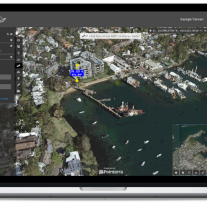
High resolution 2D aerial imagery of Australian metro areas. This plane-captured, high-currency, orthographic imagery can be used to facilitate length and area measurements.
The High-res 2D Map is great for obtaining front and side setback dimensions, building and site areas, zooming in on features seen from the air, drafting shapes on a map for master planning and for briefing the LARKI sales team and other stakeholders.
Use the High-res 2D Map to scope areas for 3D Point Cloud data orders.
Try the LARKI web app features free of charge, such as:
High-res 2D Map – aerial imagery of Australian metros, ideal for briefing stakeholders, front and setback dimensions, building and site areas, zooming in on features seen from the air, and drafting shapes for masterplanning.
3D Viewer – navigate around and measure 3D Point Clouds and BIM from your web browser, with tools like crop, horizontal cut, section, coordinates, length and area dimensions, annotate and draw in 3D.