3D Streetscape Point Cloud

Front facades and features from the street

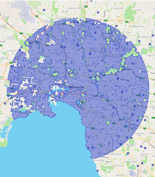
Medium resolution, colourised 3D point cloud data, captured from a 3D laser scanner on a car (LiDAR). Great for:

Streetscape point cloud image

Affordable. Convenient. Fast.

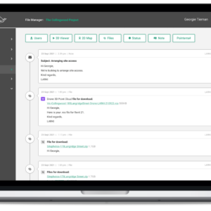
Order, pay for and download 3D Aerial & Streetscape Point Cloud data online today. 

Starting from $165, delivered within hours. 

LARKI - 3D Survey - Products

Why use a 3D Streetscape Point Cloud for your next project?

More than 1,300km² of 3D Streetscape Point Cloud Data in our database across Melbourne, Sydney and Brisbane

Melbourne

Abbotsford
Aberfeldie
Airport West
Albion
Alphington
Altona
Armadale
Ascot Vale
Ashburton
Ashwood
Avondale Heights
Balwyn
Banyule
Bellfield
Bentleigh
Box Hill
Braybrook
Brighton
Brooklyn
Brunswick
Bulleen
Burnley
Camberwell
Carlton
Carnegie
Caulfield
Chadstone
Clifton Hill
Coburg
Collingwood
Cremorne
Deepdene
Doncaster
Eaglemont
Elsternwick
Elwood
Essendon
Fairfield
Fawkner
Fitzroy
Flemington
Footscray
Gardenvale
Glen Huntly
Glen Iris
Glenroy
Gowanbrae
Hadfield
Hampton
Hawthorn
Heidelberg
1 of 4

Sydney

Abbotsford
Alexandria
Allawah
Annandale
Arncliffe
Artarmon
Ashbury
Ashfield
Balgowlah
Balgowlah Heights
Balmain
Banksia
Banksmeadow
Bantry Bay
Barangaroo
Bardwell Park
Bardwell Valley
Barra Brui
Beacon Hill
Beaconsfield
Belfield
Bellevue Hill
Belmore
Beverly Hills
Bexley
Birchgrove
Bondi
Botany
Breakfast Point
Brickfield Hill
Brighton-Le-Sands
Bronte
Brookvale
Burwood
Burwood Heights
Cabarita
Cammeray
Campsie
Canada Bay
Canterbury
Carlton
Castle Cove
Castlecrag
Centennial Park
Chatswood
Chifley
Chippendale
Chiswick
Chullora
Clemton Park
Clontarf
1 of 10

Brisbane

Acacia Ridge
Albany Creek
Albion
Alderley Heights
Annerley
Arana Hills
Archerfield
Ascot
Ashgrove
Aspley
Balmoral
Banyo
Bardon West
Belmont
Bennelong Heights
Boondall
Bridgeman Downs
Brookfield
Bulimba
Bunya
Buranda
Camp Hill
Cannon Hill
Carina
Carindale
Carseldine
Chandler
Chandlers Corner
Chapel Hill
Chelmer
Chermside
Clayfield
Clifton Hill
Coopers Plains
Coorparoo
Corinda
Darra
Dorrington
Durack
Eagle Farm
Edenbrooke
Eight Mile Plains
Enoggera
Everton Hills
Fairfield
Ferny Hills
Fig Tree Pocket
Fitzgibbon
Fortitude Valley
Geebung
Glen Kedron
1 of 7

Send an
enquiry

Have a question? Keen to know more?
Send us an enquiry and we’ll be in touch!

Not seeing what you need?

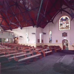
We can also provide 3D Aerial, Exterior Tripod, Drone and Interior Tripod Point Clouds, Building Information Models (BIM),
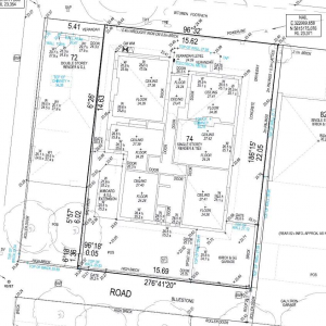
2D Feature Plans, 2D Title Re-establishments and 3D Planning Envelopes.

14 Day FREE Trial of the Platform*

No credit card details required!

*$45 off max discount per 3D Data order.

Try the LARKI web app features free of charge, such as:

High-res 2D Mapaerial imagery of Australian metros, ideal for briefing stakeholders, front and setback dimensions, building and site areas, zooming in on features seen from the air, and drafting shapes for masterplanning.
3D Viewer – navigate around and measure 3D Point Clouds and BIM from your web browser, with tools like crop, horizontal cut, section, coordinates, length and area dimensions, annotate and draw in 3D.
image 38 1