Feature surveys set the scene for every architecture and property development project.
The pressure is on land surveyors to provide comprehensive site information so the developer can evaluate the site’s potential and so designers and planners can do their work efficiently and effectively. Delays to the project add costs to the project and therefore decrease the affordability of new buildings for end consumers.
LARKI is the perfect partner for land surveyors to streamline workflows. Fast affordable 3D laser scans from the LARKI database are a game changer for every land surveyor, giving you a competitive edge before you even get to site.
A new workflow is to download existing Aerial and Streetscape 3D Point Clouds, already in the LARKI Platform, before you go to site. As a surveyor, you can assess this data, so that you do not need to spend as much time on site and also less time drafting in the office. You can check the quality and accuracy of the 3D Point Clouds, and even use these 3D Point Clouds as a reference for more detailed drafting.
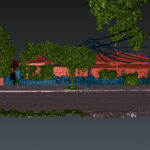
Many surveyors trace aerial photos when generating their feature surveys. Aerial photos miss the 3D information required for a detailed feature survey, such as the features under trees and awning roofs. Rather than tracing aerial photos, surveyors can now use 3D Point Clouds to understand parts of the site they were not able to measure on site due to access or time constraints.
Development success starts with a detailed survey
Before any project can begin, designers and developers need a detailed understanding of their project site.
This is where the brilliance of land surveyors and spatial technology comes in. Using a variety of surveying tools, they take measurements on site then process and output those measurements into a format that designers can use.
A feature survey – whether a 2D plan or a 3D scan – provides spatial information about the existing conditions of a site, including the shape and dimensions of features like ground contours, roads, powerlines, trees, buildings, windows, fences and more.
The information collected in the survey is the foundation for the rest of the project’s design, approval and construction documents. Feature surveys are used by architects, landscape architects, planners, engineers, builders and councils to make decisions about the design of a project, as well as issuing relevant documentation and permits.
Having enough existing condition feature information is absolutely essential during the design stage!
A feature missed, like a neighbouring window, powerline clearance or parapet height, can lead to big problems later on, costing clients time, money and effort to fix. For example, a missed lean on a power pole could mean building too close to a powerline, leading to failed building inspections and extremely costly reworks in construction.
The pressure is on land surveyors to provide accurate survey information right at the beginning of the project and to provide it quickly, so that architects, engineers and other consultants can begin delivering their work.
Manual single point surveying is too slow
Creating a detailed 2D feature survey the old-school way takes time. When only manually collecting one data point at a time, land surveyors spend too much time on site with a total station, writing notes and taking photos.
The more data points collected on site, the more detailed the resultant survey plan will be… but also the more time the surveyor has to spend on site.
Depending on the weather, site access restrictions, health and safety, and time pressures from competing projects, as a land surveyor it can be challenging to manage your time effectively in order to get the right financial reward.
Back in the office, land surveyors have to spend more time joining the dots to make the 2D survey plan. This is when gaps or discrepancies in the information come to light. You then have to go back to the site, or make an educated guess using phone photos, and tracing aerial or satellite imagery.
But phone photos are not measurable.
And plane or satellite imagery has limitations. For example, you can’t see what’s underneath balconies, awnings and eaves, and sometimes they are not accurately orthographically adjusted.
It’s a frustratingly inefficient process for surveyors and anyone who depends on their inputs.
More detail and accuracy doesn’t have to cost more
Errors in the initial feature survey can lead to lost confidence from architects and engineers trying to progress and coordinate their designs.
For example, an architect may assume that the straight line drawn between 2 points on a survey plan notating the location of a wall actually means that the wall is straight when in fact it is not. The site data points captured by a total station on site can indeed be millimetre accurate at the exact height and location that point was taken from, above or below that random height, the point might be in a different location on the plan. Moreover, the line drawn between those 2 points may be proportionally speaking more accurate than accurate, and in fact the same is true for the entire plan. So 2D feature survey drawings by their nature of being line drawings are mostly more diagrammatic than they are accurate representations of reality. You can provide the 3D Point Clouds to give context to the 2D feature survey drawings and create a more accurate representation of reality.
Inaccuracies can also lead to big problems later on, costing stakeholder time, money, professional indemnity, job losses, and even litigation. And subsequently damaging your reputation and credibility as a land surveyor.
There is a better way!
Especially when there is site complexity, and you just can’t gather enough information within the job budget and time. It’s a stressful and time consuming process to begin with. And then when you have to deal with questions and additional requests for information, it can very quickly start eating into your profit margin.
With LARKI, you don’t have to supplement your site survey with affordable 3D laser scan data, which can be ordered online and downloaded in minutes. It’s fast and affordable, and helps streamline your survey workflow.
Where a registered surveyor is required, make sure you use a registered surveyor, or Contact LARKI and they will put you in touch with a trusted survey partner in your area.
Cut down the 2D plan grunt work and provide scans without adding cost!
By downloading Aerial and Streetscape 3D Point Clouds already in the LARKI database, you can reduce the amount of time on site and in the office drafting. 3D laser scans have been captured once in far more detail than a surveyor ever could with a total station, minimising the need to revisit the site due to missing measurements.
When on site, you can focus your time on confirm geo-positioning and accuracy (in reference to MGA and AHD) and mapping those high-value information items that will benefit your client the most, like awkward boundaries, hidden services, and features that have been recently changed.
Instead of wasting your time pinging hundreds of coordinates – one point at a time – you can capture some check dimensions on site, then use a combination of LARKI’s Streetscape 3D Point Clouds and Aerial 3D Point Clouds to identify all the detailed features in between, such as the extent of trees, windows, powerlines and roof slope. Take check coordinates at tight enough intervals (say every 10m) to give you confidence that the point clouds are accurate enough for your client’s purposes, with a bit of redundancy, but no more, so you can save your time.
Time saved means higher profits or less fees which will contribute to reducing the devastating effect of skyrocketing property development costs.
Using the LARKI Platform, you can also share the 3D survey with your client, along with your points of interest, coordinates, measurements, and annotations in bookmarked views, to help explain valuable insights about the site’s features.
It’s the perfect way to streamline your workflows and give you more time to focus on high-value information that will benefit your clients the most!
Simply log in to LARKI to order Aerial and Streetscape 3D Point Clouds online. If available for your site, you can view and download within minutes!
There’s more information about our products and membership discounts on our website and in our brochure. Reach out to a member of our team and book a demo!