Property developers require detailed site information to maximise their site yield or return on investment.
Property development is a multi-stage process involving a calculated assessment of risk and return. Of the many variables that determine the final profit, one of the largest and most important, is what you pay to acquire your development site in the first place.
Time is money. In a hot market, you need to move fast to secure your finances and make an offer to the vendor or bid at auction and get the architecture project underway.
How can you evaluate the development potential of a specific site, quickly and efficiently, without a large investment of time and money to commission detailed site measurements?
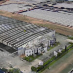
At LARKI, we know the answer to that question starts with a 3D Aerial Point Cloud to show you the broad context of the neighbourhood from above with the ability to measure building heights and setbacks. Even better, you can have this information within a matter or hours starting from only $150+GST and it’s compatible with all architectural software packages.
You need a massing study to determine highest and best use to forecast your site yield
Property developers work in an increasingly competitive environment trying to squeeze value out of every cubic centimetre of their urban development sites in an effort to maximise site yield.
The better the information at the start of the project, the more accurately you can assess the full development potential of your site.
A typical first step is to ask an architect to prepare a massing study to determine the project’s overall shape, volume and floor area.
This massing study with floor areas enables a feasibility study by the developer to calculate how to fit in the best mix of say residential units to retail/commercial and common space. In this way, you can quickly establish some preliminary estimates against sellable or lettable floor areas.
From there, you can estimate your anticipated sales revenue and your building costs, apply your developer margin, and reverse-engineer how much to offer for the site as the residual land value.
It’s a crucial first step.
The massing, areas ratios, uses programme and feasibility assessments also determines the highest and best use for the site and enables a more detailed business case to pitch to financiers and other stakeholders.
As you don’t know yet whether you are going to bid for this site, let alone be the winning bidder, it’s hard for the developer – and the architect – to justify investing a large amount of time and money at this stage.
Often a developer will ask an architect to do the massing study “on spec” in the expectation of getting the paid commission in due course. For a few different reasons, this puts the architect in a difficult position.
The main challenge for the architect is how to obtain the necessary spatial information about the site and its surroundings in order to do the massing study. Other challenges include how to balance the investment of time and resources on a project that might not pay fees.
Without having the right information, there is a real risk that the project could be set up to fail. It’s a frustrating situation for both the property developer and the professional architect.
Your architect needs detailed spatial information about your development site and its surroundings
Your architect can generate a 3D massing study and floor area mock-ups using spatial information about your site and its surroundings together with their knowledge of the planning code.
The kind of information your architect needs includes local building heights, setbacks, land slope, lot size and roof morphology in the neighbourhood; all of which you might be able to get rough estimates from some online sources.
However, more fine grain site context information that is also critical for accurate massing designs and property development assessments includes smaller elements that require clearances around them in 3 dimensions, limiting the buildable area like – heritage facades, sight lines, trees, rocks, chimneys, powerlines, doors and windows to name a few. For increasingly complex and competitive urban infill, close-enough-is-good-enough will not cut the mustard anymore. You need detailed site information.
The old typical approach would be to make some back-of-the-envelope assessments working with information that is freely available. For example, the real estate agent selling the property may have provided some photographs and approximate 2D drawings, but without a visit to the site, it’s hard to interpret this.
Even with access to the site, architects can’t accurately measure neighbourhood precedents like the height of multi-storey buildings or inaccessible neighbouring property features.
Take the increasingly common example in our Australian capital cities of a developer buying two or more contiguous houses with a view to redeveloping as medium- or high-density. But how can you measure the building’s height with various hipped roofs? Or a setback dimension that is under a tree canopy not visible in aerial photos? And how can you tell if the site has any unusual vegetation, heritage, powerlines or topographical features that requires a reduction in buildable volume?
The short answer is that you can’t!
And in any case, what your architect really needs is an accurate digital version of all these existing conditions in a format that can be read by 3D architecture software (like BIM).
With an investment of time and money, you could hire a land surveyor, but this is still not the right solution because typical 2D land surveys only show about 100 site data points and always miss information such as elevational detail.
Miscalculating development potential is a costly risk for both the developer and the architect
Sadly, property developers and architects compromise, making do with quick sketches that can be metres out (when normal architectural tolerance is under 20mm). As a consequence, there is a very real risk of making the wrong decision about the development potential of the site.
You may not be able to fit in that extra space, room or even top floor you were hoping for!
Incorrectly estimating the amount of floor area will throw out all your calculations and you may find you have committed to a project that will not be profitable.
Miscalculating development potential is a costly risk for the developer who must bear the financial consequences. For the architect, there can be reputational damage and business viability risk if the initial assessment is flawed on a number of occasions.
So what’s the solution … is there a better way?
The solution is a 3D Aerial Point Cloud purchased online from LARKI
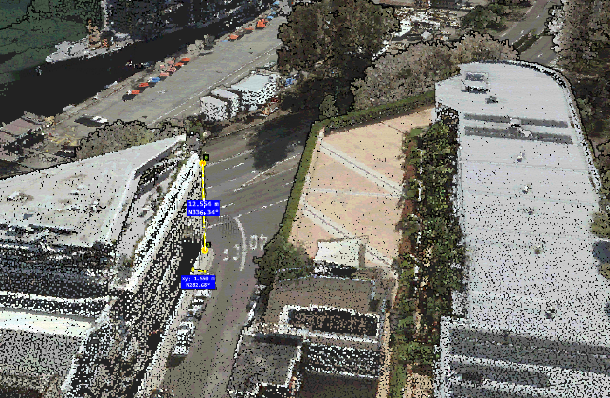
With LARKI’s 3D aerial laser scanned point clouds, you get millions of measurable data points.
You can simply buy online in only a few clicks.
In fact, we already have thousands of square kilometres of data in our library for Sydney and Melbourne (and more cities coming online soon!). It’s affordable, fast, and compatible with all standard architectural software programs (like BIM).
You don’t need to spend time with in-person measure-ups or trying to understand 2D surveys. And your architect won’t have to count bricks to estimate heights or guess-timate from photos!
A 3D Aerial Point Cloud shows the broad context of the entire neighbourhood, as seen from above. It’s a medium resolution, colourised 3D point cloud data, captured from a 3D laser scanner (LiDAR) on plane.
It’s perfect for property developers to measure existing condition building heights and for architects to kick off massing studies as well as other uses such as urban design, master planning and planning permit site context information.
For even more detail, the 3D Aerial Point Cloud can be coupled with the 3D Streetscape Point Cloud. That extra digital detail of the two data sources brings even more clarity and confidence.
The ease and accuracy of 3D Point Cloud data can make all the difference to your project’s financial success by opening up the potential for another room, an extra apartment, or even a whole additional floor level.
It’s clear that a small amount of upfront investment in 3D data delivers a substantial reward for any property developer seeking to maximise site yield.
Find out more about 3D Aerial Point Clouds and LARKI on our website or get in touch to book a demo!