Trying to navigate a tight path to the building site? Don’t risk hitting something! Use a 3D Streetscape Point Cloud for a buildability assessment. Or for transport engineers who need to assess how to get large loads to the site safely. Getting this wrong can literally be lethal!
We routinely help builders, engineers, architects and property developers to understand the existing conditions of a site and this includes putting together a buildability analysis.
Checking a site’s buildability and clearances for large-load deliveries
Buildability and how you get materials and machinery to the site are significantly impacted by the existing condition of your site, surrounds and roads leading to your site.
Building materials are often large and bulky, such as roof timber trusses and load-bearing steel beams, and they are transported on large flat bed lorries that require a minimum amount of height clearance and turning circle clearance.
The construction process may also involve large items of equipment and machinery needing to be safely brought in – and then moved out – by road. For example, a bulldozer, an excavator, a grader, a trencher, a crane, a pile borer, a cherry picker, a forklift truck, skip bins… and more. It is also important for a builder to know where he can store materials and machinery on site.
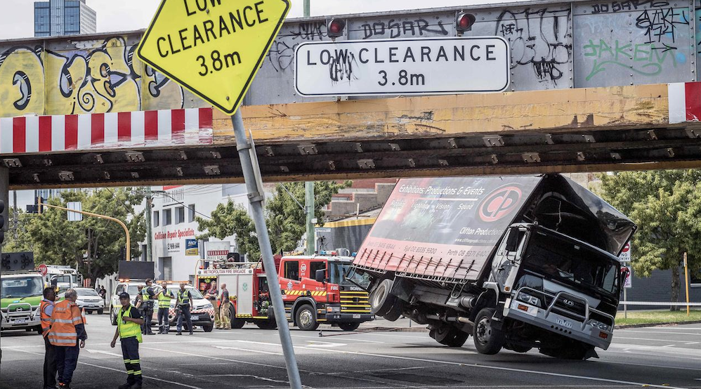
Materials, machinery and humans are precious cargo! As a builder or transport engineer, you have a standard of care to perform a transport risk assessment on the route that will be used to move the item in and out of the site. Site access must be checked thoroughly in order to avoid delays and reworks after construction has commenced. This means understanding powerline clearance, bridge clearances, how the land slopes, where there are trees and curbs, and in dense urban areas you also need to survey the adjacent buildings. , such as fences, power lines, overhanging trees and low clearance spaces such as underpasses and tunnels This is important to know so you can specify any necessary tolerances and safety precautions for delivery of goods to the site.
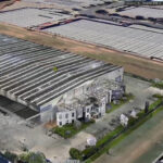
To perform a buildability assessment, the builder needs to know that it is possible not only to source the necessary materials but also to get them safely to the site with all necessary equipment. This means knowing the lie of the land not just for the site but also for the surrounding neighbourhood and roads.
Traditional surveys are slow, expensive, and only in 2D, plus they will always miss details.
And it’s impractical to do a traditional survey on an entire street or neighbourhood!
You might think you have sufficient working space on-site for everything … and you might be right … or you might be in for a nasty surprise. Unfortunately, that’s when there can be arguments with the client, the neighbours, the authorities and worse problems like delays, costly reworks, litigation or even site accidents. And the later into the construction process before you get this site information, the more costly it is to fix. It is not worth the risk.
Don’t risk your precious goods!
The main task is to identify any contact or collision hazards that may be encountered along the way. The main need is to get this information quickly and accurately but there can be business challenges in terms of travel, human resources and affordability.
Buildability and transport risk assessments require a lot more information than simply using a sat-nav to map the shortest or quickest route. Or even worse, the totally slapdash method would be simply to use Google Maps Street View. If you are far from the site, how do you quickly send a person out in a passenger vehicle mounted with a dash cam, a mobile phone camera and a sketch pad to perform a physical reconnoitre.
Unfortunately, this physical route assessment is slow and expensive. Moreover, it leaves a lot of room for human error and it’s only in 2D.
The main weakness is that the results are not accurately measurable and, at the end of the day, without the proper vertical, horizontal and 3D measurements of the route, the transport risk assessment is not defensible.
There could be an accident that results in damage to property. Worse than that, there could be an injury – or even death – caused to workers and members of the public.
The transport risk assessment could become an important legal document if there is an accident because there will be an investigation, there may be criminal or civil legal action, as well as an insurance claim.
For everyone involved to sleep soundly at night, you need more than human guesswork and an expensive insurance policy. You need professional integrity and confidence. And that means you need a 3D Streetscape Point Cloud.
What can I see in a 3D Streetscape Point Cloud?
The easy solution to facilitate a buildability assessment or a transport risk assessment is to log in to LARKI and order a 3D Streetscape Point Cloud online. We’ll have it ready to download in only a matter of hours.
We can provide 3D Streetscape Point Cloud data for nearly every road in Australia and New Zealand (except for private roads or small lanes).
You can see just about anything that is visible to the eye via an unbroken line of sight from the perspective of a car on the road.
For example, you’ll see 3D laser scanned data of existing natural features such as trees, rocks and cliffs, as well as built features like curbs, powerlines, fences, facades, doors, heritage detail, building decorations and window frames.
In fact, you’ll be able to do more than just see it … you’ll be able to measure elevations, fences, crossovers, building heights and setbacks with accuracy. And this can be done anytime anywhere via vertical, horizontal or 3D measurements in our 3D Viewer web app.
You can even buy several consecutive kilometres of 3D Streetscape Point Cloud data so you can have a full virtual view and take measurements of everything along the transportation route.
Additionally, you can add a 3D Aerial Point Cloud and layer up your data sources using our platform to view and manage all your files.
LARKI’s solution is affordable, convenient and fast. You can order, pay, view and download our 3D Streetscape Point Cloud data online and have it delivered within hours. It’s also compatible with all major architectural software programs.
There is no need for in-person site measure-ups and you can significantly reduce the risk of costly delays and reworks and save all the unwanted time, hassle and reputational damage that goes with that.
Find out more about 3D Streetscape Point Clouds and LARKI on our website or get in touch to book a demo!