At LARKI, we are proud of our positive impact on the environment and society because you can’t do a proper environmental or heritage assessment without knowing accurately – and in detail – what is actually there.
Traditional 2D land surveys always miss information, so you won’t properly capture the actual shape of trees, rocks or heritage detail. Unfortunately, that means your environmental and heritage assessments may not actually be achieving their objectives. Worse still, you may end up with objections that you cannot readily answer, or even find yourself in litigation that you cannot easily defend.
These issues are addressable by starting your project off with a highly detailed 3D laser scanned survey so you have the best information about what is actually there on your building site and the surrounding neighbourhood and you also have the right inputs for your Building Information Model (BIM).
What’s going into your BIM?
BIM can help with simulations of shadow studies for lighting, light irradiation for solar panels, and wind vectors for natural ventilation.
It’s a valuable technique to help architects, builders and property owners understand how to build sustainable and comfortable buildings that benefit from natural light and cross-ventilation, and can additionally maximise opportunities to be energy efficient too.
However, as we all know, model outputs are only as good as their inputs. For the best results, you need to know the actual shape of trees and built features in the neighbourhood that will overshadow the sun or impair the breeze.
Point clouds are the right inputs for BIM because you won’t get the accurate results from 3D techniques when using low resolution 2D inputs.
The 3D laser scans (or LiDAR) that LARKI can deliver – quickly, affordably and conveniently online – are the most detailed form of reality capture so you can be assured you’re not missing anything and focus on your project with confidence.
What is laser scanning and how does it make a 3D survey?
As the digital age constantly advances, there are more and more processes which were previously the industry standard that are being rendered obsolete, or at the very least much less effective compared to the newer technology. For example, traditional 2D topographic surveys when compared with 3D surveys via laser scanning.
Laser scanning is an extremely effective way to survey large and complex environments.
Plus it’s safer and faster.
3D laser scanning is a highly detailed and accurate, non-contact and non-harmful land surveying technology which allows for the shape of physical structures and objects to be digitally captured using beams of laser light.
It is increasingly impractical and unaffordable for surveyors to choose to go to site and physically capture data given the time, the cost, and the lack of accuracy, compared with the richness of data points with 3D methods like laser scanning.
When something is laser scanned, millions of 3D data points are recorded which provide a highly detailed and accurate depiction called a point cloud. The level of density in points is so high and colourised, that the data can now provide almost photo realism that can be navigated around in 3D as well as giving users the ability to accurately measure the captured features.
Unlike other land surveying methods which only capture a single individual point at a time, 3D survey laser scanners can capture approximately one million points each second.
Details from every angle can be recorded and used as a base to create highly accurate point clouds, CAD drawings and BIM.
Point clouds can be easily integrated into concept designs or proposals as is. This allows for accurate measurement and inspection without manual modeling.
Better data collection delivers accuracy which improves confidence and solves the issue of having to undertake multiple site visits in order to answer additional questions or respond to design variation requests.
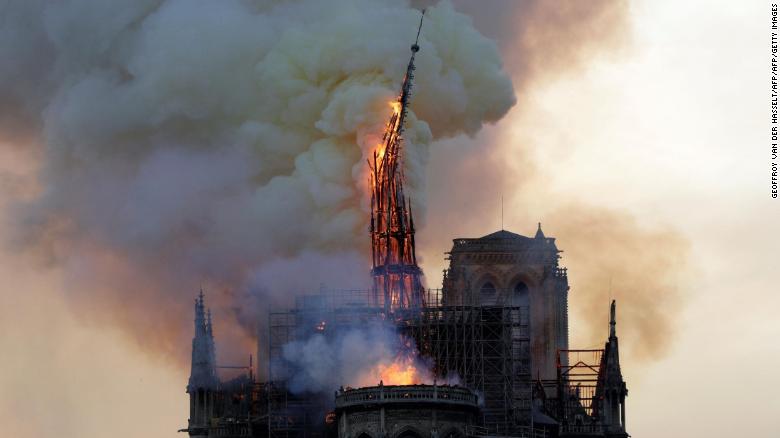
Heritage records and reconstruction – the amazing Notre-Dame case study
The data gathered from 3D scanning create a permanent snapshot of that moment in time on site for reference or archive as a dimensionally accurate representation of reality that can be viewed and measured digitally at a later date, from anywhere, on an as-needed basis.
This makes it perfect for heritage records and reconstruction.
The most widely known example of this is Notre Dame Cathedral in Paris which caught fire in April 2019. Thankfully, in 2015, a tech savvy art historian called Andrew Tallon used laser scanning to record the inside and out of the magnificent Gothic church. That data is now invaluable as it is physically impossible to return to the pre-existing site.
(Sadly, Tallon passed away in 2018, so he never got to realise the amazing legacy that he left the world.)
Save time and money by purchasing 3D point clouds online from LARKI
There are significant time and cost savings by having access to all of your site data as a 3D point cloud, ready to check at any time, from anywhere.
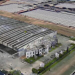
LARKI’s 3D Aerial Point Clouds show the broad context of the neighbourhood from above. They are great for understanding neighbourhood precedents, building heights and setbacks.
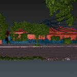
For the lateral context, 3D Streetscape Point Clouds show front facades and features from the street. You can see streetscape elevations, signage and fencing, and heritage details like wrought iron balcony railings, bay windows, sash windows, sandstone bricks, and other decorations. You can also see natural environmental and landscape features such as rocks, slopes, and actual trees (not platonic circles as tress are often represented in plans; trees are far from circles).
Both of our products can simply be ordered online from the website and downloaded – normally within 2 hours – for use in your architectural software (like Revit, ArchiCAD, Vectorworks, etc) or use our online 3D Viewer.
There’s more information about our products and membership discounts on our website and in our brochure.
You can also reach out to a team member and book a demo.