LARKI recently held a virtual event introducing LARKI’s 3D laser scan data (Point Clouds), high-resolution map ordering interface (High-res 2D Map) and data management platform (Dashboard).
If you missed it, you can view the event video online to learn how LARKI is revolutionising spatial information for the architecture industry:
LARKI Platform Launch Event Video
Alternatively, we’ve summed up the key features and benefits of our Platform here.
Summed up, LARKI offers exceptionally detailed 3D surveys online. So what does this mean for you?
- Architects, our 3D data and viewing tools can save days of your time modelling
- Planners, LARKI can save you weeks of assessment
- Property developers, the Platform can save you months of project time, which can translate to tens of thousands of dollars
With the high-tech LARKI Platform, you can get fast and affordable high-resolution 3D spatial information for architectural design. You don’t need to visit the site to measure up manually anymore. Instead of a traditional land survey costing around $2,000 and waiting 4 weeks. LARKI has 3D plane-captured data – 3D Aerial Point Clouds – for as low as $250+GST that we can provide in around 1 hour.
This is approximately:
- 700 times faster &
- 8 times cheaper
Moreover, we have a 3D Viewer on the Platform so you can easily view information online, anytime, anywhere.
With LARKI you can access data at the click of a button for most sites, particularly around Melbourne and Sydney.
So let’s recap the key product features and benefits discussed in our virtual event.
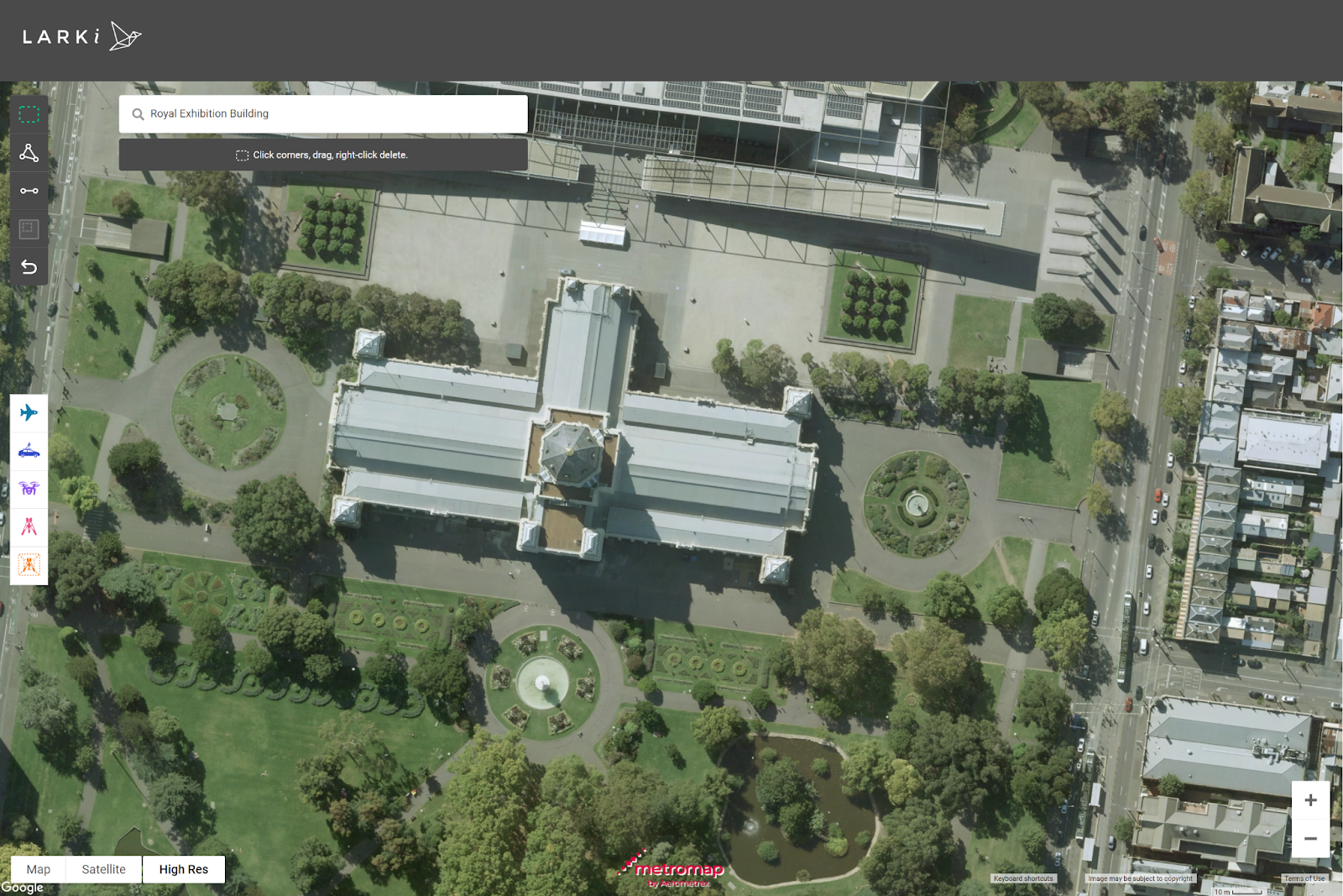
High-res 2D Map
The LARKI Platform has a 2D map which also includes 2D high-resolution aerial photos as an underlay to help with inspecting the site and measuring lengths and areas. LARKI partners with Aerometrex’s MetroMap 2D service to offer orthographic imagery captured from low flying aircraft. New aerial images are taken frequently in metro areas (every quarter or so), and this high-res aerial imagery exists for most of Australia’s populated areas (covering 95% of the Australian population).
Ellie Zoghi from MetroMap 2D explained the key benefits of 2D aerial image technology:
- Our 2D high-res aerial photos offer 5cm high resolution to zoom in (with greater detail than standard Google Satellite view).
- With more frequent image capture, at many times per year (compared to upto years out of date with the standard Google Satellite view).
- Ability to measure lengths and areas.
- With LARKI’s 2D Map, it also offers an easy way to see what 3D Point Cloud data is available on the map.
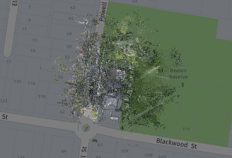
3D Aerial Point Clouds
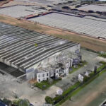
Alex Rixon took us into 3D Aerial Point Cloud data, as offered through MetroMap LiDAR technology. LiDAR (or light distance and ranging) is a 3D mapping technology that uses a laser beam to capture the shape and location of physical site features. Laser pulses emitted from a laser scanner attached to aircraft are transformed into a dense three-dimensional point cloud output file. These 3D Aerial Point Cloud files show details like trees, buildings, fences and power lines; which can benefit applications in architecture, urban planning and utility modelling.
The key benefits of 3D Aerial Point Clouds are:
- Low-cost when compared with all other 3D data capture technologies (such as tripod, drone, mobile or even traditional 2D total station data capture.)
- LARKI now has approximately 900 km² of mainly Melbourne and Sydney data in the database for sale, which means a super quick turnaround of roughly 60 mins from order to delivery of the file from the LARKI Platform.
- 3D Aerial Point Cloud data is captured from a plane flying over at speed. It is a great option for large areas where medium detail and medium accuracy is not a problem – such as for broader site context information.
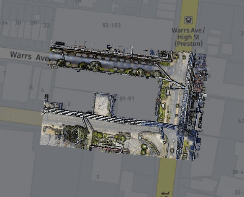
3D Streetscape Point Clouds
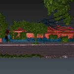
Nick Preston from Here Technologies (another one of our data partner companies) – explained the benefits of LiDAR captured from a car with a 3D laser scanner mounted on the roof. Otherwise known as Mobile Laser Scan data, these 3D Streetscape Point Clouds offer spatial information at the road level, including building facades, powerlines, trees, roads, curbs, crossovers, street furniture and anything that can be seen from a car driving down the street.
The main benefits of 3D Streetscape Point Cloud data are:
- It’s low-cost due to the large amounts of data that can be captured while driving along.
- Great for determining information about facades and streetscapes for architectural and urban planning projects especially for streetscape elevations for planning permit applications where medium detail and accuracy are sufficient.
- LARKI now has approximately 600 km² of Melbourne, Sydney and Brisbane, in the database for sale. This means a super quick turnaround of roughly 60 mins from order to delivery of the file from the LARKI Platform.
- You can also apply through LARKI for existing 3D Streetscape Point Cloud data that may be available all over Australia, New Zealand and well… globally!
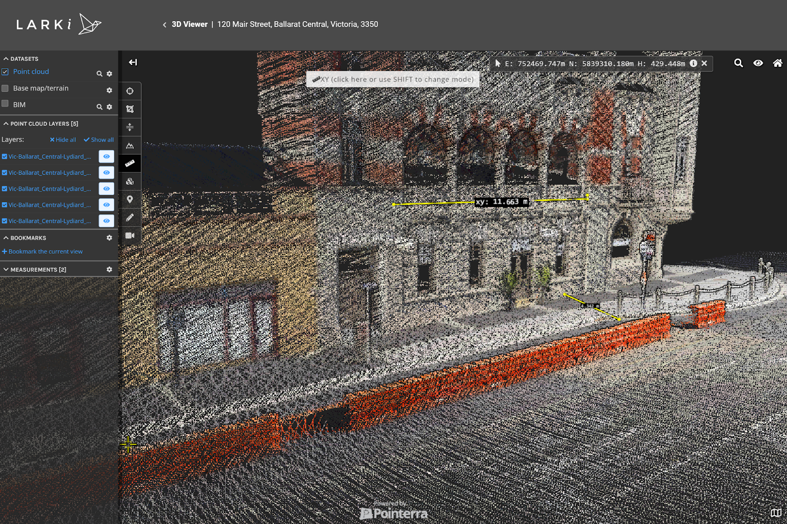
3D Viewer
LARKI’s 3D Viewer is a web app that helps to bring your 3D Point Cloud data to life, so you can access and measure your site anytime, anywhere. This is where it all comes together, to make the magic happen.
Powered by Pointerra, the main benefits of the 3D Viewer are as follows:
- Navigate around your site remotely.
- View your site in 3D, cropped, plan or section.
- You can establish AHD coordinates and take vertical, horizontal or 3D measurements.
- Data purchased from LARKI will be pre-loaded into the 3D Viewer app for you.
Measure and annotate online, which means no more multiple site measure-ups!
Learn more about our different subscription models to suit your budget and needs, or get in touch to book a demo and see for yourself how LARKI can save your next architecture project time and money.