Not able to get to site quickly in person to do measure-ups?
Not able to dimension complex forms like heritage, trees, rocks, powerlines?
Not having the spatial site information you need right now?
Your inability to measure things at heights or out of reach?
Not having an accurate existing condition 3D file that works in your 3D software?
Wasted days onsite – yourself – when you have better things to do?
Doing risky and time consuming things like counting bricks to estimate heights?
Wasting hours interpreting 2D land surveys, scaling, rotating, changing line types?
Wasting hours setting up BIM projects with the correct coordinates and orientation?
Having arguments with authorities, objectors, and builders over site dimensions?
Reworks due to incorrect or lacking measurements costing the project thousands?
Nervous about errors risking your insurance, relationships and even litigation?
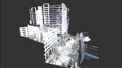
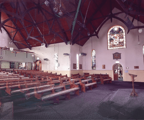
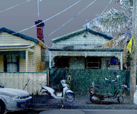
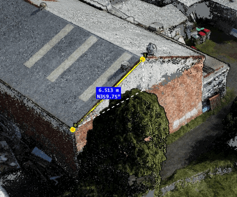
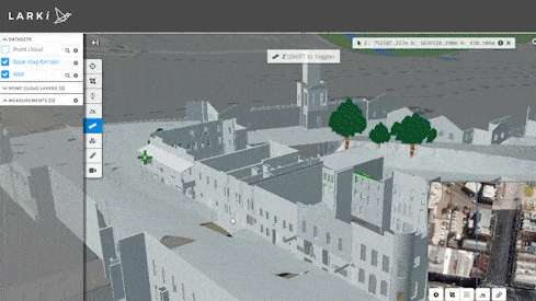
Compared to traditional low detail 2D feature surveys, with LARKI’s exceptionally detailed 3D laser scanned surveys you can now see in great detail: tree branches, power lines, window frames, heritage details, brick grout lines, and more. The output file of a 3D laser scanner is the 3D Point Cloud file. You can now use these high resolution 3D Point Cloud files in your 3D architectural software or even in the 3D Viewer on the LARKI Platform web app.
Planners, clients and builders love 3D Point Clouds too because they can see the rich character of the buildings, site, streets and surrounding neighbourhood. Everyone, regardless of their training or background, can intuitively understand 3D easily. Any stakeholder can view the 3D and they are equipped to make quick decisions because they just get it. Imagine these critical design and planning decisions taking minutes instead of months.
Don't put up with it!
Don't waste time
going to site
Save time modeling &
drafting
Stop costly delays &
reworks
Try LARKI’s industry leading 3D Point Cloud Data, Service and Platform now!
Enjoy 3 months of the LARKI Membership for FREE (valued at $297)
Save 30% on 3D Data purchases online
3D Viewer to measure existing features online
High-res 2D Map Aerial imagery online
and more!
CLAIM YOUR FREE 3 MONTHS MEMBERSHIP
Used by the Best
The 3D Data and expertise provided by LARKI is trusted by Australia’s most
reputable architects and property developers.
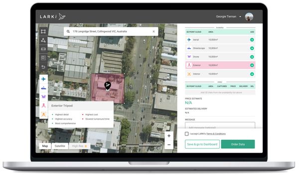
3D Point Cloud Data
Get the most detailed way to capture reality 3D laser scanning. With files optimised to work in your architectural design software.
Get millions of site data points captured from a combination of 3D laser scanners on tripods, drones, planes and cars. Delivered to you via an online platform. Optimised for your architectural software – Revit, ArchiCAD, Vectorworks, AutoCAD, Rhinoceros and many other industry standard tools.
Interior Tripod 3D Point Cloud
This is the highest resolution and accuracy 3D Point Cloud, captured from a 3D laser scanner on a tripod, covering the outside areas of your site and surround, as you require. A Site Deployment is required where a team goes out to scan the scope area. This is the ultimate solution when you need know with certainty what is on your site. For BIM enabled architects, this 3D point cloud can be used instead of a site measure-up, so you can design with precision to maximise site yield
Exterior Tripod 3D Point Cloud
This is the highest resolution and accuracy 3D Point Cloud, captured from a 3D laser scanner on a tripod, covering the outside areas of your site and surround, as you require. A Site Deployment is required where a team goes out to scan the scope area. This is the ultimate solution when you need know with certainty what is on your site. For BIM enabled architects, this 3D point cloud can be used instead of a site measure-up, so you can design with precision to maximise site yield.
Drone 3D Point Cloud
Captured from a drone flying about 30m above your site. A Site Deployment is required where a team goes out to scan the scope area. The drone data is great for areas that can’t be captured from a tripod, such as roofs or over high fences, to give you a more comprehensive view of the site and surrounds. Drone data is also great for larger areas where the Aerial data is not available.
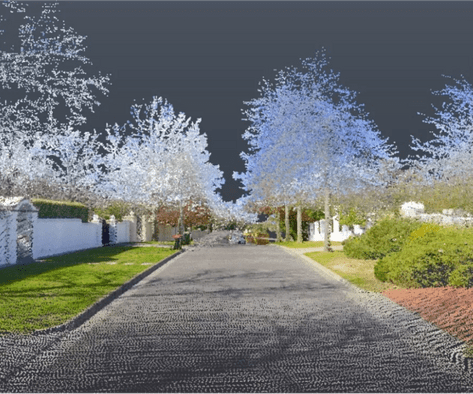
Streetscape 3D Point Cloud
Captured 3D laser scanners attached to cars driving past down the road. This affordable data and so quick to download or measure online within only a few hours. Great for seeing front facades, front fences, crossovers, curbs, powerlines, nature strips, street trees and anything you can see from a car driving down the street. Just show the Streetscape 3D Point Cloud instead of wasting all day doing a streetscape elevation.
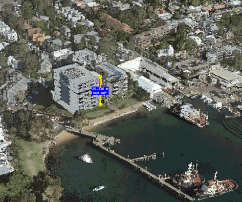
Aerial 3D Point Cloud
Captured from 3D laser scanners on planes flying over at about 3000m. This is the more affordable data and so quick to download or measure online within only a few hours. Great for understanding the broad context of your neighbourhood. Just show the Aerial 3D Point Cloud instead of wasting all day mocking up existing massing and estimating building heights and setbacks.
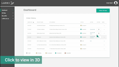
Platform
Use the LARKI Platform to order, track progress, share, download, view and measure your 3D Point Clouds and other files online.
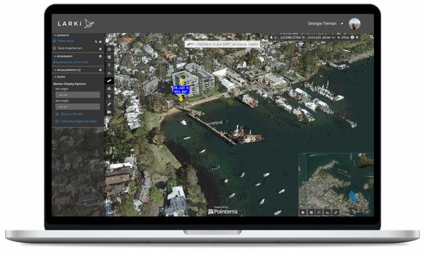
3D Viewer
Navigate & measure the 3D Point Cloud and BIM from your web browser, anytime, anywhere. This 3D Viewer, powered by Pointerra, lets you crop, section, measure, annotate and get coordinates to Australian Height Datum (AHD).
Hi-res 2D map
High-resolution aerial photos as an underlay on the 2D Map, facilitate length & area measurements. This plane-captured, high currency, orthographic imagery, is powered by MetroMap 2D and available for most metro and regional towns, so you can zoom right in to see recent detail in 2D.
Services
LARKI can provide Services such as scan-to-BIM – converting your laser scanned 3D Point Clouds into components in an architectural models, such as: BIM Terrain, BIM Walls, BIM Windows & Doors, and more. LARKI can also provide 2D Feature Plans and other surveying. Please enquire using the form above to find out how we can help you with your existing condition information effort.
Happy Customers
"LARKI 3D surveys really saved us time. All the necessary information was collected in great detail, allowing us to work with confidence and avoid having to return to the site to re-measure. LARKI 3D surveys is really a game changer."
Petar Petrov
Director - Petroff Architecture
"LARKI’s 3D Point Clouds gave me turbo design wings, I could think quickly, while also precisely problem-solving within Revit."
Marina Kozul
Director - Studio Konstruct
"Whoa! This point cloud survey is next level!...LARKI has allowed us to design with certainty and precision around existing conditions. We see their 3D point clouds as essential tools in any architects workflow."
James Murray
Director - Tandem Architecture
Talk to one of our expert team and start receiving industry
*For new customers only. 30% off Data is for purchases of Aerial and Streetscape 3D Point Clouds you make yourself on the LARKI Platform. Offer is only available to customers who attend a live demo of the platform. Customer Terms & Conditions apply. This is a limited time offer, fill in the form now to avoid disappointment.